
Walk a Grapevine Street Directory
A Grapevine address must be carried from one record system to the next. Start with the property record, because it supplies an account number, a property address, and a legal description. Then use the map to make sure the parcel is the one intended. A deed search can tie recorded parties and dates to that legal description, while a city permit can date work at the site. These records establish different facts. Recorded ownership is not the same as a current mailing field, a project applicant, or a person physically present.
- Enter the full address in the Tarrant Appraisal District property search and save the account number, property address, legal description, subdivision, and instrument shown.
- Check the location in the Tarrant County Public Map Viewer or CAID. Confirm the parcel outline and compare nearby street labels before relying on a result.
- Use the legal description, prior owner name, document number, or date in the Tarrant County Official Records Search. Read the linked instrument when one is available.
- For a city development date, consult Grapevine's public-records routes, WebLink, or the Report Center for permits, Certificates of Occupancy, and code reports connected to the site.
- When the chain reaches an older address form, move to deed-history cards, tax rolls, library microfilm, maps, and the archival counter rather than guessing from a modern street number.
Keep a simple worksheet with the original address, normalized address, account, legal description, instrument number, date, and source. It lets another reader repeat the check at the proper custodian. Note: a precise address makes the street-by-street chain easier to reproduce and reduces false matches.
Grapevine Parcel Record Fields
Tarrant Appraisal District is the appraisal and parcel route, not the office that records deeds. Its result table can display an account number, geo reference, property address, property city, primary owner name, and market value. An expanded card can add current owner information, primary owner address, legal description, state code, georeference, subdivision, neighborhood code, TAD map, Mapsco, instrument, and notice or value details. Search modes support account number, address, and owner name.
The field that matters most for an older street search is often the legal description. A parcel is the defined tract used in property records. The situs address is the address assigned to the property itself. It can differ from the primary owner's mailing address. That difference is important: a mailing field does not establish occupancy at the Grapevine street address.
| Search field | How it helps a street search |
|---|---|
| Property Type | Choose among Residential, Commercial, Mineral, and Personal Property. |
| Enter Your Search | Begin with a complete address, account number, or owner name as the portal supports. |
| Account # | Use this stable property key when comparing TAD, the tax office, and map tools. |
| Geo Reference | Helps check the parcel's map context. |
| Legal Description | Supplies subdivision, block, lot, or other terms needed when a historic address fails. |
The TAD property-search screen shows the starting point for this Grapevine street directory route.
Move from the result to the property card before copying a legal description or instrument reference into the next search.
Grapevine Mailing Address Fields
Insider tip: keep the property address and the primary owner mailing address in different worksheet columns. TAD displays both because they serve different purposes. A mailing field may direct tax correspondence to a trust, an estate, a business, or another location. The situs field identifies the property addressed by the appraisal record. Neither field, standing alone, verifies who is physically present at a Grapevine address.
This distinction prevents a common street-search error. Use the situs address to connect the appraisal card to the parcel map and legal description. Use a recorded deed to establish the transaction that names a grantor and grantee. If the research goal is historical, add a dated directory, tax roll, census record, or newspaper item only after preserving the source and its date. Each record then retains its own meaning instead of being blended into an unsupported claim about a household.
When a field appears inconsistent, check whether the parcel has a corner address, merged lot, or older address form. The County map, legal description, and county clerk image are better checks than changing a field to fit an assumption.
Grapevine Parcel Map Layers
The county map tools add spatial context that an appraisal card cannot show. The Public Map Viewer has Address, Account, and Owner tabs, an address prompt, parcel selection, and map layers. CAID can search by address, owner name, or tax account. Its layers can include city boundaries, voting precincts, ZIP codes, schools and districts, flood contours, property, and airports. That is useful when a Grapevine label overlaps an airport area, a boundary, or a neighboring jurisdiction.
A parcel polygon can also expose fields such as owner name, owner address, owner city and ZIP, situs address, account, TAD map, Mapsco, exemption, legal-description lines, and school. Map data is reference material, not certified title evidence. Use the polygon to make sure the address and legal description point to the same tract, then verify the recorded document through the county clerk.
Insider tip: Treat the mailing address and the situs address as separate facts on every worksheet. A Grapevine street directory search becomes misleading when either is converted into a claim about who lives at the property.
The Tarrant County parcel viewer is the visual check between an address search and a recorded-document search.
Use parcel selection and layers to test geography, then save the account and legal description for a custodian-level record check.
Grapevine Address Records by Street
No single Grapevine street directory lists every present or former household. The appraisal card, GIS layer, deed index, voter tool, city files, and historical material use different keys and update on different schedules. Combining them carefully produces a transparent address history without turning an inference into a personal claim.
| Address record | Custodian | Useful key | What it can show |
|---|---|---|---|
| Appraisal card | Tarrant Appraisal District | Address or account | Current owner display, mailing field, legal description, and property details. |
| Parcel map | Tarrant County GIS | Address, account, or owner | Parcel outline, situs field, account, map references, and geographic layers. |
| Official records | Tarrant County Clerk | Party, legal phrase, document number, or date | Grantor, grantee, recording details, book or page references, and images when offered. |
| City development files | City of Grapevine | Address, project, or document | Permit, Certificate of Occupancy, or code-report context. |
| Registration lookup | Tarrant Elections | Name, address, or ZIP where applicable | Registration, precinct, and polling context subject to protections. |
Tarrant Voter Lookup is a registration and polling tool, not a street roster. Protected voters and Address Confidentiality Program participants may not appear in the ordinary form. Likewise, a permit connects an applicant or project to a site and date, not necessarily a resident. Note: retain the source date because county and city systems do not refresh together.
Grapevine Street Deed Chain
The Tarrant County Clerk's Official Records Search supplies the recorded-document trail. Quick Search includes department, search term, recorded-date range, date shortcuts, and index-only or index-and-full-text options. Advanced Search adds party names, grantor, grantee, document number, book or volume or page, image phrase, and legal searches. For an address that does not work as a search term, switch to the subdivision, block and lot, abstract, legal phrase, or recorded parties from the appraisal card.
Work backward from a current recorded grantee to the prior grantor, preserving each document number and legal description. The county says the online portal was certified through August 28, 2026, but the precise earliest online-image date was not stated. Archival material documents grantor and grantee deed indexes from 1876 to 1920, and historic ledgers add older land and property material. That boundary is the point to use deed-history cards, tax rolls, archives, and library microfilm.
The Official Records Search is the index used to locate a recorded instrument in the Grapevine street directory trail.
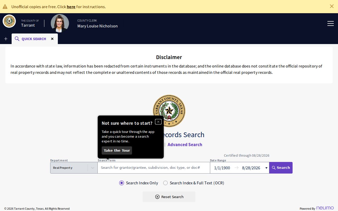
An index hit is a lead, not a title conclusion. Inspect the image or obtain an official copy from the County Clerk before relying on the instrument.
Grapevine Permit Dates by Address
City records can add a date bracket to a property trail. Grapevine's public-records page says permits and Certificates of Occupancy are updated in the Report Center, and code-enforcement reports are available there as well. The city's WebLink system can be browsed or searched. Its development browse route exposes residential and non-residential modes with a long street list that includes Main Street North and South, Wall Street East and West, College East and West, and Dallas Road East and West.
Use a permit or certificate to understand work, use, or a project at an address. Do not treat the applicant as proof of residence. If an item is not in the online material, contact the City Secretary or submit a written Texas Public Information Act request describing the address, date range, project number, or document sought. Grapevine accepts written requests by email, public-information portal, fax, mail, or in person.
Grapevine Streets Need Old Names
Historic address work needs name normalization. A 1924 annexation included College Heights, Berry's Lane, and western property around Grapevine or Keller Road, now West Wall. Morehead Street became Texas Street. City historic-district material also uses labels such as Main, College, Wall, Dallas Road, Dooley, and Scribner. A historical file may use a district, landmark, former street label, legal description, or surrounding feature instead of the number used now.
Compare the old and current forms against the city's historic-district maps and the 1885 Tarrant County map, then return to the legal description. Maps are research aids, not surveys. For past occupants, the Grapevine Library's 1972 directory and selected Dallas telephone-directory years can supply an address lead, but the collections themselves are described on the Grapevine City Directories page. Note: a changed street name is a reason to widen the search, not evidence that a property vanished.
Grapevine Street Records Access Routes
Online tools are only the first branch of an address search. Use TAD, the county map viewer, Official Records, city WebLink, and the public-records page for current public interfaces. If a result is missing or needs an official copy, call the Tarrant County Clerk or TAD before making a trip. The County Clerk offers official-record copies in person at Room B30, free watermarked online copies after a free account, certified online copies with account and payment, and a mail route for a requested document number.
For the mail route, the county asks for the document number, a self-addressed stamped envelope, payment by cashier's check, check, or money order, and its listed per-page and certification charges. For city permit or report material that is not posted, use the City Secretary's written Public Information Act process. A request should identify an existing document, date range, project number, or address well enough for the city to search. It is not a request for the city to create a street roster.
Older street research has another set of doors. The Grapevine Public Library Genealogy Room provides readers, microfilm, a scanning station, and staff contact for local material. Tarrant County Archives has historical maps, city directories, and land or property ledgers, while TSLAC and FamilySearch extend tax and deed research farther back. This layered access chain is why an empty portal page is a stopping point, not the end of a Grapevine street directory inquiry.
Grapevine Street Directory Limits
A street-by-street search cannot prove every person connected to an address. Appraisal records can show owners and mailing fields. Deeds show recorded transactions. GIS shows mapped parcels. Voter results have their own registration and confidentiality rules. City permit material may identify an applicant or project. Each source has a narrower meaning than the broad claim that someone lives at a location.
Texas protects some voter residential addresses, and ACP participants use substitute addresses. The Texas Public Information Act opens existing government records unless an exception applies, but it does not require an office to create a resident list or disclose protected material. When a result is absent, it may reflect privacy rules, indexing limits, a changed street form, or a record held by another custodian.
Lawful use. Use Grapevine address records for family history, property history, civic research, or verification of an official filing. Do not use any result to stalk, harass, threaten, or harm another person.